1 Digital Innovations and Machine Learning
Part 1: Automated Modelling of Masonry Wall Facades Using Digital Documentation
Research Undertaken by Post-doctoral Researcher Dr Enrique Valero, Dr Frédéric Bosché and Dr Alan Forster 2015-2022
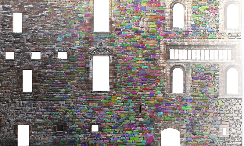
Linlithgow Palace courtyard west wall, 3D-coloured point cloud.
This research project focused on creating accurate and cost-effective digital building fabric inspections for conservation and maintenance, using terrestrial laser scanning data.
The project developed innovative computer vision methods for the processing of digital 3D data of the masonry to identify the individual stones and the mortar regions, both in ashlar and rubble masonry structures. Mortar recess is also estimated.
This allows rapid and accurate quantification of, for example, the number of stones in a façade and the quantity of mortar required for re-pointing (see image). Automatic statistical review of stone sizes and shapes also supported the study of phases of construction and interpretation of building histories.
Following this project, the rubble masonry segmentation algorithm that was developed has been made freely available to the heritage and construction sector. These algorithms have significant practical value for improving accuracy, speed and objectivity of historic façade inspections.
A plugin has also been developed for the widely-used open-source software package CloudCompare to allow automatic and semi-automatic segmentation of rubble masonry facades and output results in formats useful to, for example, architectural technicians and building surveyors.
While this research is driving forward our conservation and maintenance within the properties we look after, it has the potential to fundamentally transform conservation practice within the wider heritage sector.
Find out more in our recent publications and read our press release to celebrate the launch of the Cloud Compare plugin:
- Automatic segmentation of 3D point clouds of rubble masonry walls, and its application to building surveying, repair and maintenance (ScienceDirect)
- Masonry segmentation plugin for CloudCompare (The University of Edinburgh DataShare)
- Masonry CloudCompare Plugin announcement (GitHub)
- New innovative technology launched to help care for Scotland’s traditional buildings (Historic Environment Scotland press release; 22 May 2020)
Part 2: Automated Defect Detection and Classification in Masonry Facades Using Digital Documentation and Machine Learning
Research Undertaken by Post-doctoral Researcher Dr Enrique Valero, Dr Frédéric Bosché and Dr Alan Forster 2018-2022
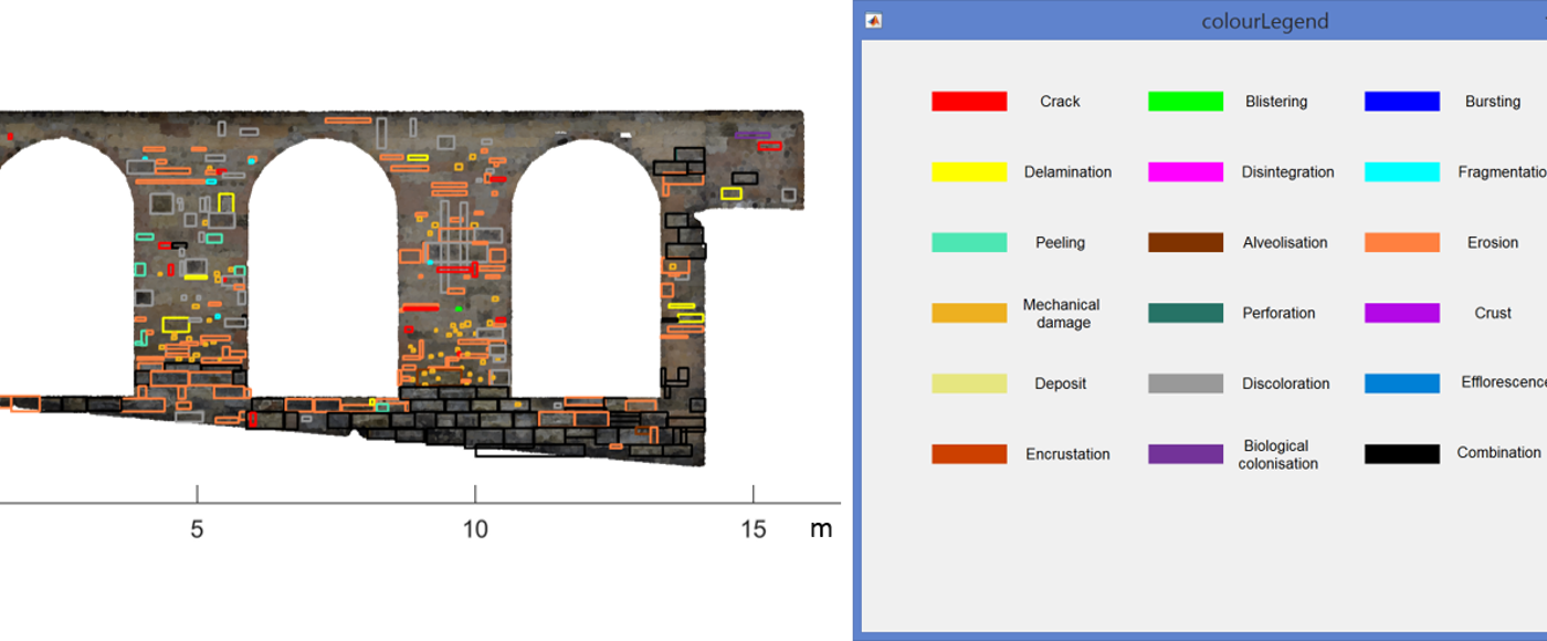
Defective areas in a masonry wall, as labelled by surveyors.
This research project contributes to the collaboration’s aim to create accurate and cost-effective digital building fabric inspections for conservation and maintenance, using terrestrial laser scanning and photogrammetric data at its core.
The project used machine learning for the interrogation of digital 3D data for historic building fabric condition survey to evaluate areas of deterioration. Innovative algorithms were developed to detect and classify stone wall defects, in coloured 3D data of individual stones (obtained thanks to the segmentation tool described in Part 1).
A machine learning-based model was developed that inferred the presence of surface defects or manifestations of defects (such as erosion, delamination, cracks or discolouration) based on a range of geometric and colour-based metrics.
While this research is driving forward our conservation and maintenance within the properties we look after, it has the potential to fundamentally transform conservation practice within the wider heritage sector.
Find out more about digital documentation and machine learning in our recent publications:
- Technical Paper 38: Digital documentation, computer vision and machine learning for masonry surveying and maintenance (Historic Environment Scotland)
- Automated defect detection and classification in ashlar masonry walls using machine learning (ScienceDirect)
- High Level-of-Detail BIM and Machine Learning for Automated Masonry Wall Defect Surveying (The International Association for Automation and Robotics in Construction)
Part 3: Monitoring Roofs of Traditional Buildings using Remote Sensing
Research Undertaken by PhD Student Jiajun Li, 2022-2025
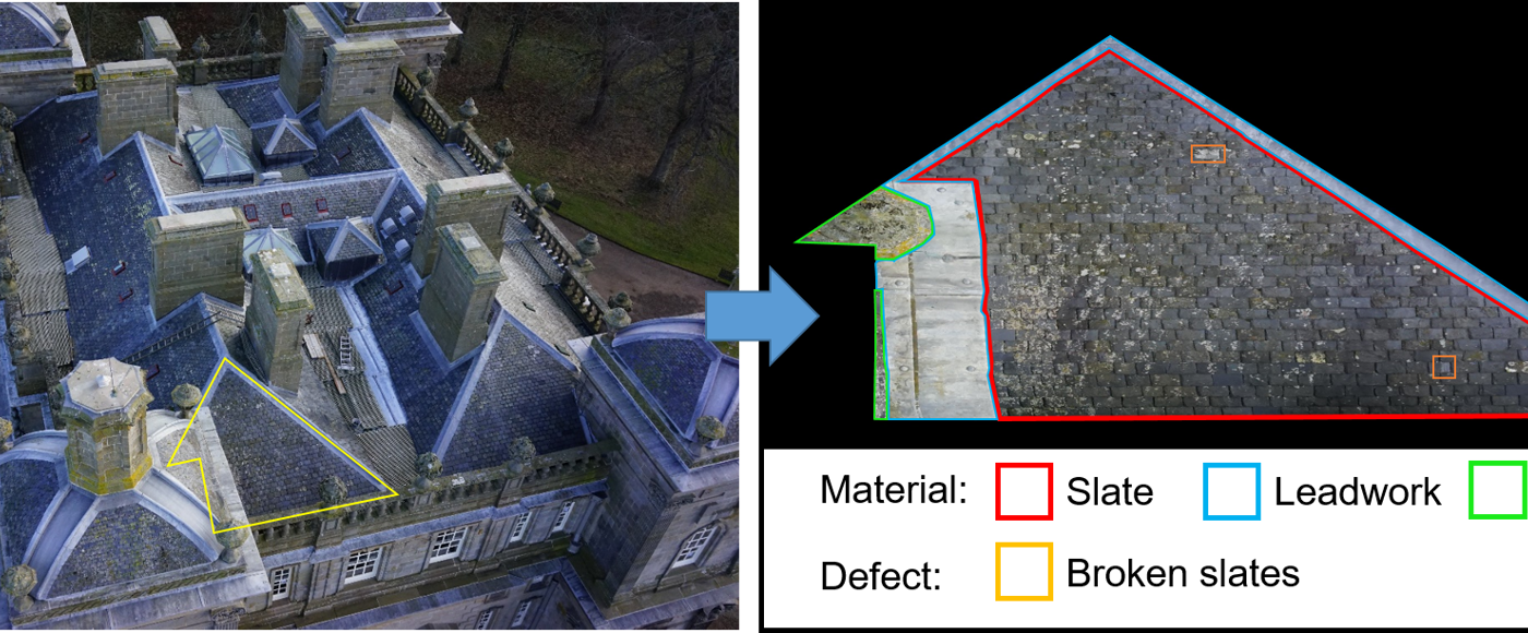
Roof defect monitoring using drone surveys and automated image processing using artificial intelligence.
Maintaining buildings and infrastructure is critical for sustainability of our built environment, the economy and the societal resilience of the region they service. English Heritage assert that every £1 invested in heritage-led regeneration has generated £1.60 in additional economic activity reflecting the under-represented financial benefit of such interventions.
Climate change projections for the UK suggest that the built environment in general and the historic/traditional built environment in particular is being placed under increasingly significant strain, which raises fundamental challenges to the monitoring and maintenance of those structures.
Such is the importance of anthropogenic climate change that in 2019, Scotland declared a climate emergency and, as a result, we published a Climate Action Plan that includes seven areas of action.
The first area is ‘Climate Impacts and Adaptation’ and it is guided by a commitment to “continue to research and monitor the effects of climate change on the historic environment. The more we know, the better we can help it to adapt”. This PhD scholarship and project are set within this area of action.
It is increasingly understood that external building fabric (roofs, walls, windows) are particularly adversely affected by climate change and extreme weather events. This PhD scholarship is specifically directed to use innovative data capture methods such as drone surveying and photogrammetry, and aims to use multiple Artificial Intelligence (AI) data analysis methods to monitor roofs of traditional and historic buildings.
The work shall first focus on the 3D modelling and semantic segmentation of roof orthoimages. Then, a roof defect detector shall be developed, focusing on defects visible on the roof surface. Finally, a Digital Logbook (or Digital Twin) for documenting roof life-cycle defect information will be built.
This research is jointly funded by us (Historic Environment Scotland) and an EPSRC Doctoral Training Partnership scholarship.
Digital Documentation Glossary
Laser scanning
The recording in digital form of the 3D surface geometry of an object. See detailed description on the Engine Shed's Digital Technologies page.
Photogrammetric Data
Photogrammetry is used to produce 3D datasets of buildings, places, and objects in our historic environment. Photogrammetric data can be represented as a collection of high-resolution 3D coordinates (a “point cloud”), or connected 3D surfaces as a 3D model. This is a digital representation of the features of the building or object photographed.
Rubble Masonry Segmentation Algorithm
An algorithm that segments a point cloud acquired of a rubble masonry structure into each stone in the structure and the mortar joints.
Roof Orthoimages
A computer-generated image in which the scale is uniform, so that it can be used to measure true distances.
Semantic Segmentation
An artificial intelligence algorithm that associates a label or category with every pixel in an image.
2 Geophysical Survey on the Antonine Wall
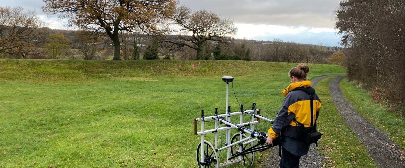
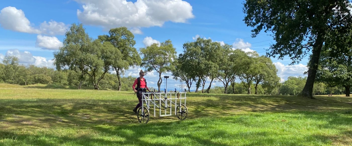
Geophysical survey taking place along the Antonine Wall.
Our 'Seeing Beneath the Ground: a Partnership for Geophysics' project began in July 2020 with five years of funding from the Historic Scotland Foundation.
The geophysical survey team uses a range of techniques including gradiometer, ground penetrating radar, earth resistance, and electro-magnetic survey to address a range of research and management questions, contributing to the development of the use of geophysical survey in Scotland.
To date the team has carried out survey work at various locations throughout Scotland, including on The Antonine Wall World Heritage Site.
Forming part of UNESCO’s “Frontiers of the Roman Empire” World Heritage Site, the Antonine Wall was the Roman Empire’s most northerly frontier and ran for around 40 miles from the Firth of Forth to the River Clyde.
It was built in AD 142 on the orders of the Emperor Antoninus Pius and consisted of a turf rampart fronted by a deep and wide ditch with forts and fortlets built along its length to house troops stationed on the frontier.
It is believed the fortlets were spaced about one mile apart along the length of the frontier, and there may have been as many as 41 fortlets on the wall when it was originally built but only the location of nine had been positively identified.
Our team used gradiometry, a non-invasive approach allowing investigation of sites within the World Heritage Site without digging holes or damaging the site in any way.
These surveys were aimed at answering a range of management and research questions posed in both the recently published Antonine Wall Research Agenda and the Antonine Wall Management Plan to help better understand this important monument. Despite the monument receiving centuries of detailed enquiry, there is still much to discover.
Geophysical survey taking place along the Antonine Wall.
In winter 2021 our team visited Carleith Farm, West Dunbartonshire, a site towards the western terminus of the frontier. A reference from 1707 by antiquarian Robert Sibbald mentioned that he had seen a fortlet in the area, although archaeological excavations in the 1970’s and 1980’s did not find any trace, and its exact location remained unknown.
The team investigated the site at Carleith Farm, and their survey identified the unmistakable footprint of the buried Roman fortlet, not far from where the excavations were carried out in the past. This discovery has led to a review of the site’s designation to ensure the fortlet is recognised and protected.
Following this success, in the summer of 2022 the team investigated the area to the west of Rough Castle, Falkirk, one of the sixteen Roman forts known along the frontier. Here the survey identified the remains of a second previously unknown fortlet raising the number positively identified from nine to eleven.
The survey carried out on the Antonine Wall shows how the application of new technology and techniques can add valuable insight to a well-studied monument and achieve the aims of the organisation's research agenda.
To find out more about the Antonine Wall World Heritage Site and what research questions still need to be answered, the Society of Antiquaries of Scotland has drafted a Research Framework for the site.
Glossary of Geophysics
Geophysical Survey
Techniques used to identify buried archaeological remains by mapping the contrast between the physical properties of the buried archaeological remains and the surrounding soil. Geophysical survey does not disturb or damage the archaeological remains and no excavation is required for their use.
Geophysical survey techniques include:
Ground Penetrating Radar
Using radio waves to capture images of sub-surface archaeological remains, this technique is able to estimate the depth of any remains identified.
Earth Resistance
A low voltage electric current used to identify sub-surface archaeological remains by detecting different level of resistance in the soil.
Electro-Magnetic Survey
Sub-surface archaeological remains are identified by detecting changes in electro-magnetic waves as they pass through the soil.
Gradiometry
A technique that detects small anomalies in the Earth's magnetic field caused by sub-surface archaeological remains.
3 Scotland’s Contemporary Historic Environment
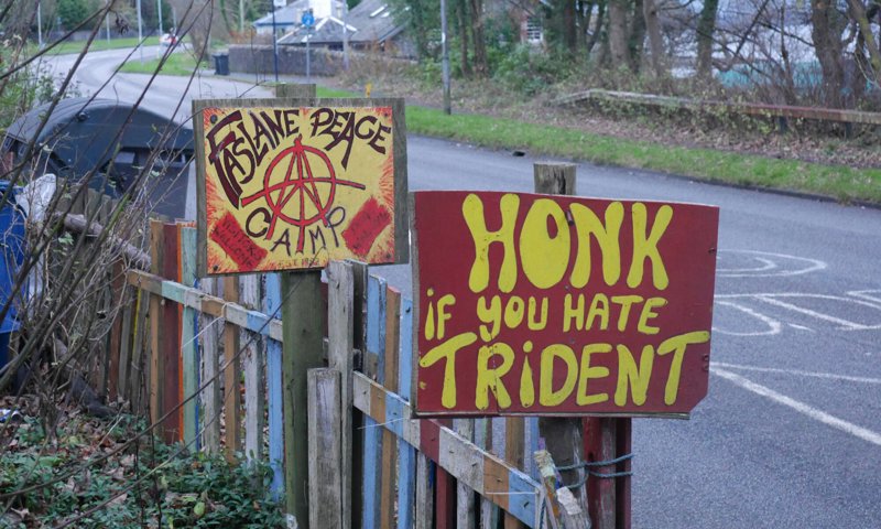
Detail of protest signs outside Faslane Peace Camp.
In a world that turns photographs into ‘click bait’ and data into revenue, how do practices such as survey, archiving and interpretation contribute to our understanding of and engagement with the past, present and future?
Ongoing research on this is helping us and our partners to creatively explore the fast-moving world we live in.
The term ‘contemporary historic environment’ is used here to describe how archaeologists and others consider the recent past and the near present as a subject to be investigated.
For example, when surveying and mapping Cold War infrastructure, beyond locating and measuring the built remains, we may interview people who worked in the sites, or we could approach places like Faslane Peace Camp and discuss ways of collaborative working based on knowledge-sharing and mutual benefits.
But approaching our work from the perspective of the contemporary historic environment also provides opportunities to explore and develop new and creative methods, frame new theories and collaborate with a broad range of partners, in order to explore what archaeology can do today for and with a broad range of communities.
In 2019, a series of research workshops funded by the Royal Society of Edinburgh (RSE) enabled people from a range of communities and practices to share their work, discuss opportunities and begin to come together around several themes that could be researched, developed and practiced under the umbrella term ‘contemporary archaeology of and in Scotland’.
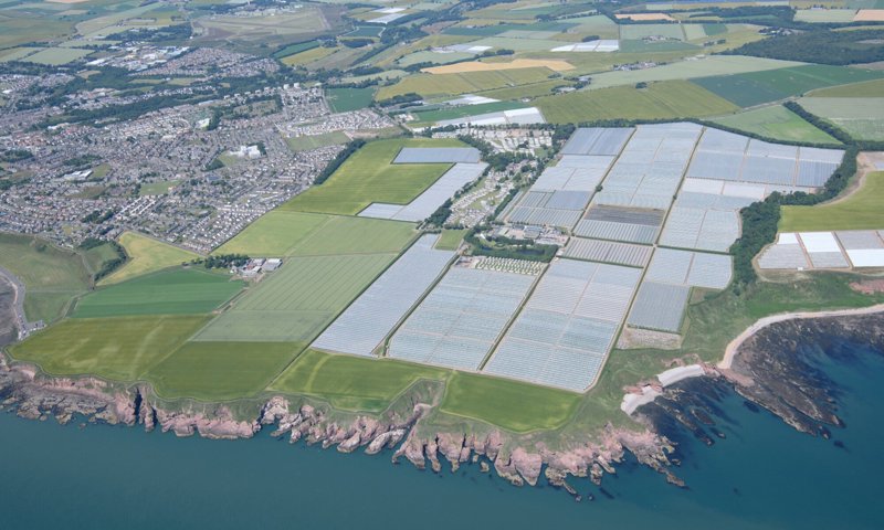
Soft fruit production at East Seaton Farm, near Arbroath, takes place on an enormous scale with polytunnels extending up to 200m in length. The permanent staff on the farm are eight Scots and 12 Eastern Europeans, with some 400 seasonal workers. The mix reflects decades of free movement within the European Union, and perhaps finding itself on the cusp of change as political decisions transform the peopling of this social landscape.
Over the past three years further RSE funding has enabled an International Research Network partnership project with the University of Glasgow, University of the Highlands and Islands, Archaeology Scotland, Glasgow School of Art and partners from over 12 countries, with a view to developing approaches for contemporary archaeology in Scotland.
The International Network for Contemporary Archaeology in Scotland (INCAScot [PDF, 25.3MB) has undertaken fieldwork, community engagement events, and workshops, and has given public talks as part of this work. Some specific project examples include:
- Contributing to the Highland region Scottish Archaeology Research Framework
- Publishing papers that explore themes of rurality, graffiti, art and archaeology, time and archives (such as a 2020 paper titled Art & Archaeology: Uncomfortable Archival Landscapes)
- Having input to our ‘intangible cultural heritage’ policy work with the aspiration of encouraging increased engagement with the historic environment for creative, socially relevant, inclusive activities.
The next stage of the project will work with the Scottish Archaeology Research Framework team to develop a suitable research approach to contemporary archaeology of and in Scotland.
At the same time, we aim to explore and define ways that the contemporary archaeology community in Scotland can contribute to the very pressing societal and environmental issues that we are facing, which are set out under the 17 United Nations Sustainable Development Goals.
4 Making More of Mapping
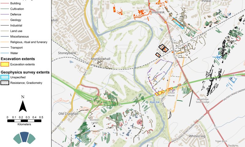
Composite map of airborne, excavation and geophysical analysis surrounding Inveresk, East Lothian.
Data created by archaeologists are essential to our understanding and interpretation of the past, but are we making the most of it?
The study of past human activity creates a wealth of information through fieldwork or scientific enquiry, all of which has a geographic component or can be linked to a specified place: this is ‘spatial data’. Each piece of fieldwork and research adds another piece to the jigsaw to improve our understanding of the past.
The annual journal Discovery and Excavation in Scotland and an initiative called OASIS ensure that discoveries in Scotland are reported promptly to the relevant local authority archaeological service and are added to Canmore: Scotland’s national record of the historic environment.
However, much of the archaeological evidence is spatial — defining where projects took place, the locations of trenches and archaeological features revealed through excavation, or mapping archaeological features in the landscape using a range of survey techniques like airborne mapping or geophysical survey.
For instance, archaeological features revealed as cropmarks can be mapped through changes in the growth of crops on aerial photographs. Or alternatively, changes in magnetic properties of the ground can detect archaeology through geophysical survey.
This information is often published as illustrations in project reports, but this is difficult to reuse for a number of reasons:
- the data are difficult to locate
- the terms and conditions for reuse are often unclear
- the data are in the wrong format – presented as dumb images (raster images) in a report rather than as vector data that can be combined with other similar data in Geographic Information Systems
- the lack of consistent data standards: the data are not described consistently, making it difficult to combine data from separate projects
Ideally, this sort of data should adhere to the FAIR Data principles, i.e. data should be Findable, Accessible, Interoperable and Reusable. In reality it seldom does. Case studies show that stepping up the management of spatial data systematically provides a return of up to 16 times the investment.
Our research shows that collating, storing and sharing archaeological data will enable archaeologists to work more efficiently and get additional value from the data. Our data will also help inform others in stewardship of the past, and will informing challenges from managing World Heritage Sites to responding to climate change.
Our research into spatial data has included several expert workshops with UK and international participants, funded through the Royal Society of Edinburgh. This work led to the publication of a Manifesto challenging the profession to develop systematic approaches to spatial data through Vision and Mission statements (McKeague et al 2020).
Vision:
We will create an environment in which spatial data from archaeological research is shared openly, maximising its contribution to the study and stewardship of the past, and engages positively with the broader geospatial environment.
Mission:
To develop a sustainable approach to collecting and sharing spatial data from archaeological research that increases efficiency within our discipline, and releases the full potential of that data to the broader geospatial environment.
Current Activity:
Through a grant from the Historic Scotland Foundation in 2023, we are now working on CHRoMA - Cultural Heritage Review on Map Accessibility. About 4.5% of the UK population have colour vision deficiency meaning that they can't easily view and understand the data we present online. CHRoMA aims to develop a more sympathetic map key for our field survey and airborne mapping data against already rich map backgrounds to improve colour accessibility.